Image Georeferencing Tutorial
Aerial Photographs, Field Sketches, Trench Maps
Crop, Tag, Georeference
Here are some simple lessons with pre-marked maps that will make you an expert in no time.
As you go through, try different basemaps (eg aerial then terrain).
Try showing / hiding boundary lines and the map centre icon.
No need to do all the lessons or add all reference points — perhaps try 1 map, 1 photo and 1 hand drawn sketch?
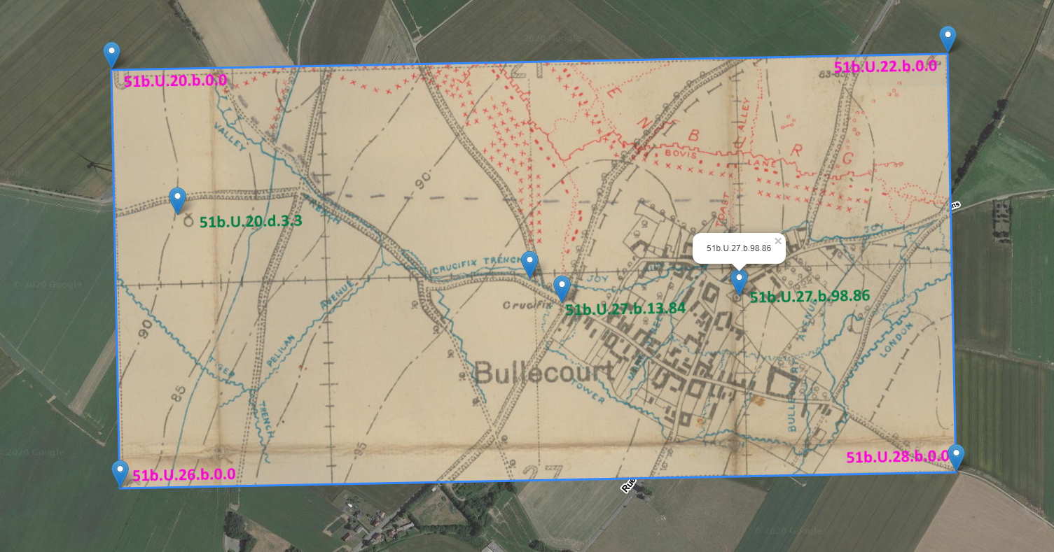
Bullecourt, April 1917
Lesson 1
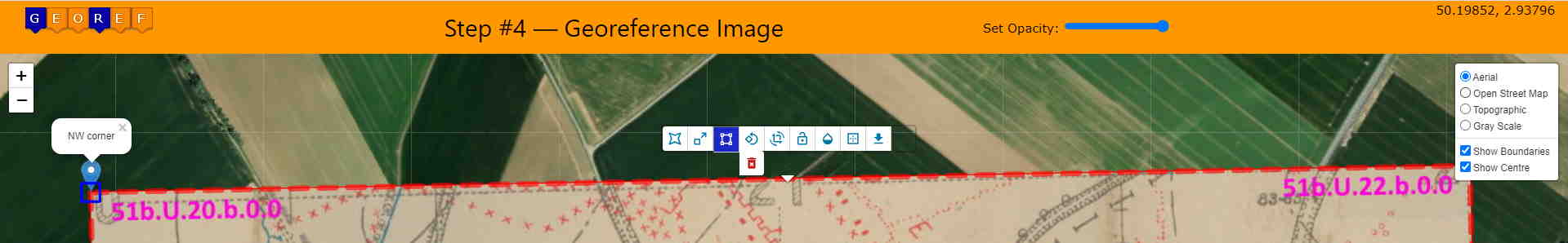
For the Bullecourt extract, first download the adjacent trench map image.
Now, start the georeferencing process:
- On the main page click the 'Choose image to upload' button and select the file you just downloaded.
- On the 'Crop Image for Tagging' page, move the cropping handles to select the entire image (or immediately click 'Tag Cropped Image' to bypass cropping).
- On the 'Tag Map for Georeferencing' page, input these values for NW, NE, SW and SE corners respectively:
51b.U.20.b.0.0
51b.U.22.b.0.0
51b.U.26.b.0.0
51b.U.28.b.0.0
- Click the 'Georef Tagged Image' button and the fitting should be pretty good.
Notes
  •An image transparency slider and current lat, lon appear on the top of the screen.
  •Use the toolbar to drag, scale, rubbersheet, rotate, zoom & rotate, lock, transparency, show border.
  •Use the floating toolbar to change map baselayers and switch on and off boundary lines and the map centre icon.
  •If all 4 corners are known, there is generally no need to adjust the fit.
  •Check modern locations underneath using the opacity slider on the top right.
  •Check modern roads at each map edge.
  •All roads appear to align except the one on the west.
  •Is the modern road slightly north? There are traces of an old road just a few metres south.
  •You can stretch corners with rubbersheeting but it's so easy to distort and make it unrecognisable.
  •We recommend this feature mainly for aerial photos & field sketches.
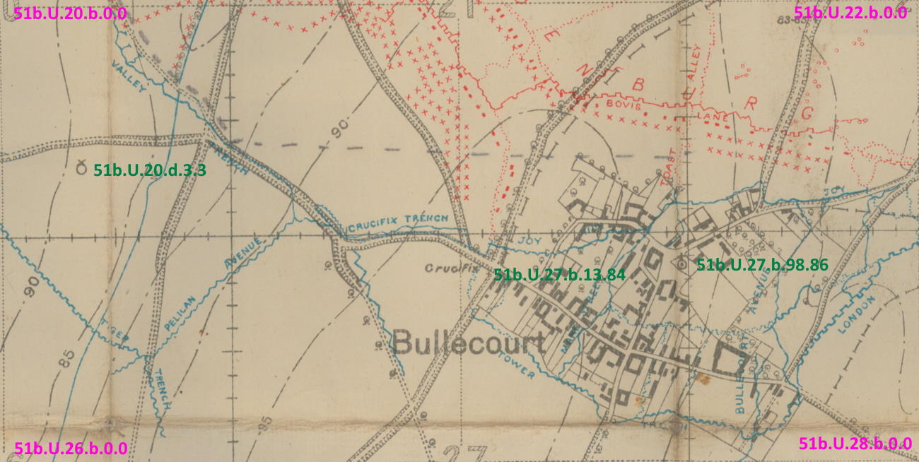
Lesson 2
For this exercise, we start the process again but only supply 3 locations.
When finished, your image should look like ours (prior to hiding the toolbar).
- Upload bullecourt.jpg.
- On the 'Crop Image for Tagging' page, immediately click the 'Tag Cropped Image' button.
- On the 'Tag Map for Georeferencing' page, find these places and type or paste in just the trench map references:
51b.U.27.b.98.86 - Église catholique Saint-Vaast
51b.U.27.b.13.84 - Crucifix
51b.U.20.d.3.3 - Old Mill
- Click the 'Georef Tagged Image' button.
- Manually rotate the image about 1° anti-clockwise after selecting the rotation symbol on the toolbar.
Notes
•Currently, the initial fit is not as good as supplying corner values.
•A small anti-clockwise rotation is a good starting point.
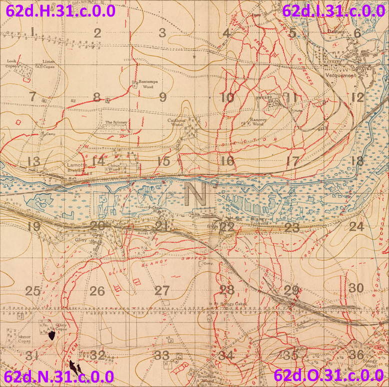
Glisy, near Amiens on the River Somme
Lesson 3
First download the adjacent trench map image.
- Click 'Choose image to upload' and select your file.
- Immediately click 'Tag Cropped Image'.
- Input these values for NW, NE, SW and SE corners respectively:
62d.H.31.c.0.0
62d.I.31.c.0.0
62d.N.31.c.0.0
62d.O.31.c.0.0
- Optionally add these reference points.
62d.N.8.d.3.9
62d.N.11.c.6.8
62d.N.21.a.9.4
62d.N.34.a.9.2
- Click 'Georef Tagged Image'.
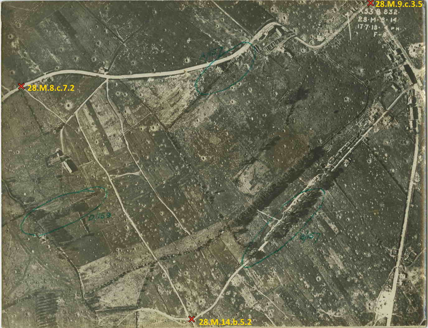
Aerial Photo — Westouter, Flanders, July 1918
Lesson 4
For the Aerial Photograph, click on the adjacent photo to download, which we sourced courtesy of McMaster University
- Upload this file.
- Immediately click 'Tag Cropped Image'.
- Input known values. We've put them on for you, but here is what you would do: Open tMapper, preferably in another screen. Use tMapper to:
- Convert 28.M.8
- In tMapper on the trench map, drag the intersection above the church in Westoutre so that it is now in the centre circle.
- Select the Main Menu icon, then Map Centre, then Trench Reference at Centre.
- Highlight and copy either the trench map or lat, lon from the message Your centre is Sheet 28.M.9.c.3.5 at 50.798350, 2.745060.
- Click on the photo you are tagging at this intersection (look for the top right ❌) and paste in 28.M.9.c.3.5 or 50.798350, 2.745060.
- Notice that a blue map marker appears over the spot.
- Follow the road westwards past Tango Buildings and the turnoff to Jupp Cottage. Just before you exit the photo there is a left turn on a track, towards a large crater. This turnoff (top left ❌) is 28.M.8.c.7.2 or 50.796994, 2.734824.
- Follow Jupp Cottage (below the large crater) south past Fransche Beek (stream) and where it meets the intersection as far south as you can go on the photo. This (bottom ❌) is 28.M.14.b.5.2 or 50.792857, 2.739781.
- When you have tagged these as either lat, lons or trench references (zooming the photo helps), you are done with tMapper and ready to move on. Your data is:
28.M.9.c.3.5
28.M.8.c.7.2
28.M.14.b.5.2
- Click the 'Georef Tagged Image' button and the fitting should be reasonable.
Notes
•Aerial photos usually exhibit some distortion.
•Aerials from an oblique angle (ie not from overhead) are currently unsuitable for georeferencing.
•Consider using the opacity slider and the two bottom controls to s l o w l y rubbersheet the photo downwards.
•When the undulating road on the bottom of the photo matches the modern road, you are done.
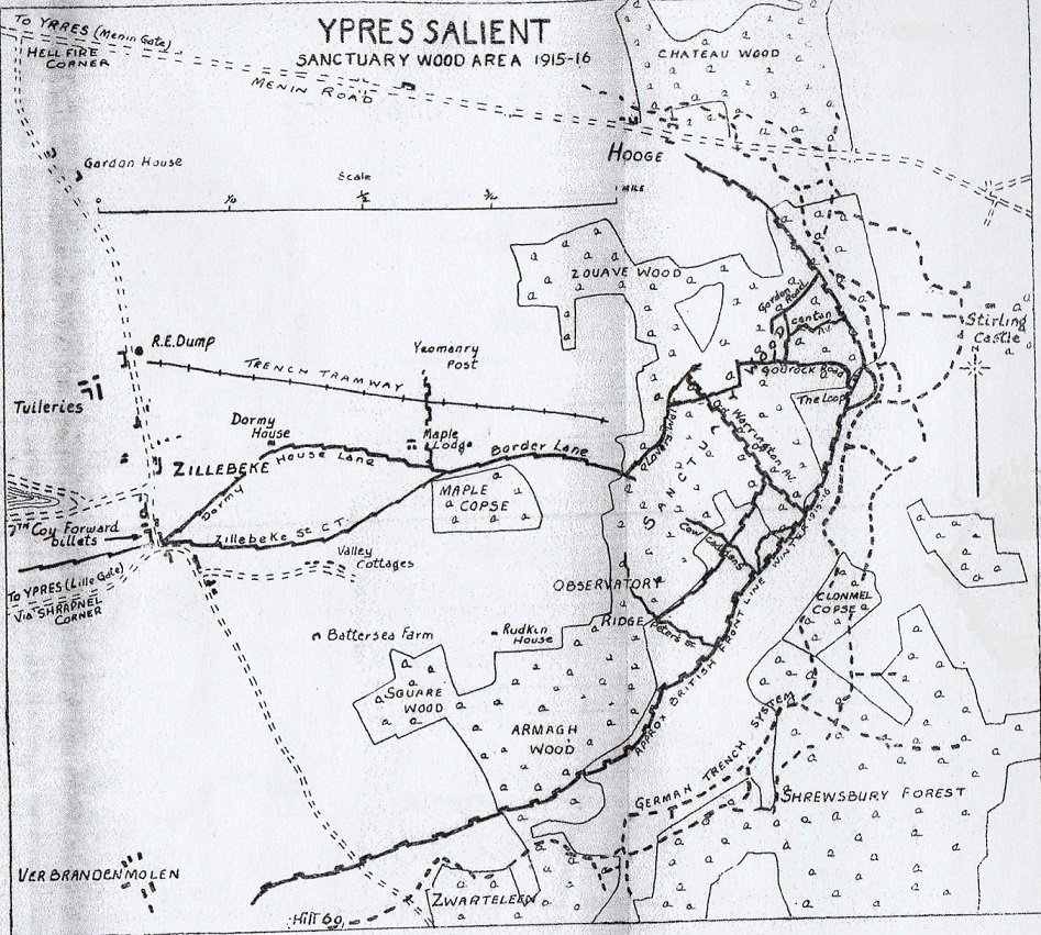
Field Sketch — Ypres Salient 1915 - 16
Lesson 5
For the Field Sketch, click on the adjacent sketch to download, which we sourced via A History of the 9th (Highlanders) Royal Scots: The Dandy Ninth
- Upload this file.
- Immediately click 'Tag Cropped Image'.
- Input known values, sourced by opening tMapper, preferably in another screen. Use tMapper to:
- Search on the term maple copse
- In tMapper on the trench map, find or search on at least 3 prominent features. Examples are shown below and the technique is described in Exercise 4.
- Click on the sketch and paste in each value.
- When you have tagged these as either lat, lons or trench references, you are done with tMapper and ready to move on. Your data might include:
28.I.23.d.80.98, Maple Copse => 50.835717, 2.935250
28.I.10.c.9.2, Hellfire Corner => 50.848834, 2.916300
28.I.24.c.0.1, Rudkin House => 50.832165, 2.936862
28.I.29.c.8.1, Hill 60 => 50.823833, 2.928883
28.J.13.d.5.2, Stirling Castle No 1 => 50.840925, 2.959132
28.I.28.d.6.5, Verbrandenmolen Mill => 50.825228, 2.921572
28.I.23.a.6.4, Dormy House => 50.837332, 2.927405
- Click the 'Georef Tagged Image' button.
Notes
•Sketches can be almost impossible to fit.
•With 7 points plotted, the fit is reasonable - our transparency slider correlates with modern roads & farms.
Improvements We're Working On
General
We are making it more forgiving, so a user can jump back and forth between pages and change values.
Upload Page
We intend to combine the first and second page so that:
- You are blocked from large uploads at the start, rather than once it has uploaded to the server.
- You don't upload a file to the server, then wait while the same image is downloaded for step 2.
- You see a progress bar while your files are being uploaded / downloaded.
Crop Page
We intend to ...
- Provide a "Proceed without Cropping" button.
- Show instructions and options (under the image) in uniform colour scheme.
Tag Page
We intend to ...
- Allow you to enter names as well as lat, lon or trench map reference.
- Let you drag icons around the map then change the underlying data (or delete the point).
- Allow you to draw a line (say 500 yards) & supply 1 reference.
- Tag features via the search engine (eg Minden Post will work now but we need a drop-down to display all choices for a term such as Post or Wood).
- Let you orientate the image to show us north.
- Fix WGS84 implementation! Latitudes (in metres from the equator) are correct but longitudes do not correlate pixels with WGS84 metres.
- Add warnings so that if you do not give us enough corners or reference points, you can still proceed, but with a stern warning that it will be an almost impossible task to georeference.
Georeference Page
We intend to ...
- Provide a Previous button
- Remove the Export Image toolbar icon.
- Add an Undo Last Change toolbar icon.
- Change to a more accurate calculation method for the map centre.